
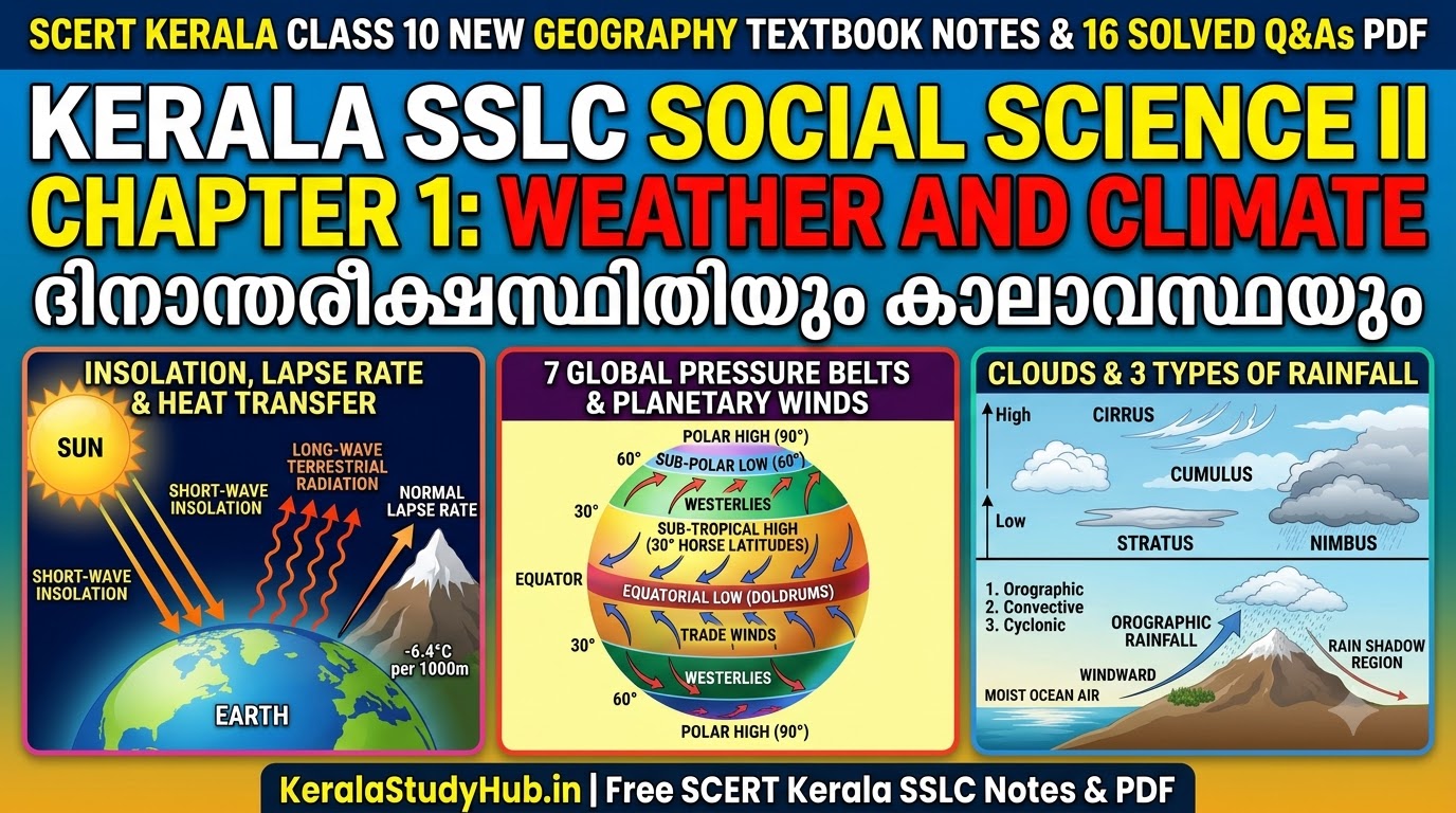
Kerala SSLC Social Science 2 Chapter 1 Notes on Weather and Climate (Malayalam Medium: ദിനാന്തരീക്ഷസ്ഥിതിയും കാലാവസ്ഥയും) welcome you to the opening unit of the newly revised Class 10 (Std 10) Social Science II (Geography) textbook published by the State Council of Educational Research and Training (SCERT Kerala). In the classroom, I always begin this unit by asking my students: “Why does a morning in Kerala start with bright sunshine, turn humid by noon, and bring a sudden downpour by 4 PM, while high-altitude Munnar stays cool all year?” In the Kerala Pareeksha Bhavan SSLC Public Examination, SCERT has combined the core principles of Insolation, Heat Transfer, Global Pressure Belts, Planetary/Periodic/Local Winds, Humidity, Clouds, and Rainfall into this single foundational chapter carrying 6 to 8 marks.
- 1. Weather vs Climate, Insolation, Heat Transfer & Factors Controlling Temperature
- 2. Atmospheric Pressure, Controlling Factors & The 7 Global Pressure Belts (ആഗോള മർദ്ദമേഖലകൾ)
- 3. Winds, Ferrel’s Law & Complete Classification of Winds (കാറ്റുകളുടെ വർഗ്ഗീകരണം)
- 4. Humidity, Forms of Condensation (Clouds) & Three Types of Rainfall (ആർദ്രതയും മേഘങ്ങളും മഴയും)
- 5. Complete SCERT Textbook “Let Us Assess” Solutions + 16 Extra Exam Questions & Answers
- Part A: SCERT Textbook “Let Us Assess” Questions and Answers (All Solved)
- Part B: Extra Sure-Shot Board Exam Questions and Answers (Q7 to Q16)
As your Social Science teacher, I have prepared this complete classroom notebook with easy-to-memorize tables, formulas for Diurnal Range and Mean Temperature, all solved SCERT Textbook Let Us Assess exercises, and 16 Full Textbook + Extra Exam Questions and Answers in both English and Malayalam Medium.
Quick SSLC Social Science & Science Navigation: Next: SSLC Social Science II Chapter 2: Climatic Regions and Climate Change | SSLC Social Science I (History) All 9 Chapters Hub | SSLC Physics Hub | SSLC Chemistry Hub | SSLC Biology Hub.
CHAPTER 1 AT A GLANCE: CLASS 10 SOCIAL SCIENCE II (GEOGRAPHY) REVISION BLUEPRINT
- Weather vs Climate & 5 Elements: Weather = short-term atmospheric condition of a place; Climate = average weather over a long period (~30+ years). Elements: Temperature, Atmospheric Pressure, Wind, Humidity, and Precipitation.
- Heat Transfer & Lapse Rate: Insolation (short-wave solar radiation) vs Terrestrial Radiation (long-wave Earth radiation — heats the atmosphere from below via Conduction, Convection, Advection, Radiation). Normal Lapse Rate: Temperature decreases by
6.4 °Cper1000 m (1 km)of ascent in the Troposphere. - Atmospheric Pressure & 7 Global Pressure Belts: Inversely proportional to Temperature, Altitude, and Humidity. Belts: Equatorial Low (`0°–5°` Doldrums), Sub-Tropical Highs (`30° N/S` Horse Latitudes), Sub-Polar Lows (`60° N/S`), Polar Highs (`90° N/S`).
- Ferrel’s Law & Winds: Due to Coriolis Force, winds deflect to their Right in the Northern Hemisphere and to their Left in the Southern Hemisphere. Permanent Winds: Trade Winds, Westerlies, Polar Easterlies.
- Instruments & Isolines: Thermometer (Temperature — Isotherms), Barometer (Pressure — Isobars), Anemometer (Wind speed), Wind Vane (Wind direction), Hygrometer (Relative Humidity), Rain Gauge (Rainfall — Isohyets).
1. Weather vs Climate, Insolation, Heat Transfer & Factors Controlling Temperature
| Concept / Process | Scientific Definition & Key Exam Points |
|---|---|
| 1. Insolation (സൗരവികിരണം) | Incoming solar radiation reaching the Earth’s surface in the form of short waves. |
| 2. Terrestrial Radiation (ഭൗമവികിരണം) | The re-radiation of energy from the heated Earth’s surface back to the outer atmosphere in the form of long waves. The atmosphere is heated mainly from below by Terrestrial Radiation! |
| 3. Conduction, Convection & Advection | • Conduction (ചാലനം): Heat transfer to the lower part of the atmosphere directly in contact with the Earth’s surface. • Convection (സംവഹനം): Heated air expands, becomes lighter, and rises vertically, transferring heat to higher reaches. • Advection (അഭിവഹനം): Horizontal transfer of heat through blowing winds. |
| 4. Diurnal Range & Daily Mean Temperature | • Diurnal (Daily) Range of Temperature = Maximum Temperature − Minimum Temperature of a day.• Daily Mean Temperature = (Maximum Temperature + Minimum Temperature) / 2.• Isotherms: Imaginary lines drawn on maps connecting places having equal temperature. |
4 Major Factors Influencing Distribution of Temperature (4-Mark Question):
1. Latitude: Tropical regions receive vertical sun rays (intense heat over a smaller area, passing through a thinner atmospheric path), whereas polar regions receive slanting rays (less heat).
2. Altitude (Normal Lapse Rate): Atmospheric temperature decreases by 6.4 °C for every 1000 metres (1 km) of ascent in the Troposphere because the air is rarer at higher altitudes and heated from below by terrestrial radiation. Hence hill stations like Munnar and Ooty are colder than Kochi.
3. Nearness to Sea (Continentality): Land heats up and cools down much faster than water. Coastal areas like Kerala experience a moderate climate (low diurnal range of temperature) due to the moderating influence of the Arabian Sea and land/sea breezes, whereas continental interiors like Delhi experience extreme summers and winters.
4. Winds & Ocean Currents: Warm currents/winds raise coastal temperatures, whereas cold currents/winds lower them.

2. Atmospheric Pressure, Controlling Factors & The 7 Global Pressure Belts (ആഗോള മർദ്ദമേഖലകൾ)
The weight exerted by air per unit area of the Earth’s surface is called Atmospheric Pressure (measured using a Barometer in millibars/hectopascals; lines connecting places of equal pressure are called Isobars). Atmospheric pressure is inversely proportional to three factors: (1) Temperature (warm air expands and rises → Low Pressure; cold air contracts and sinks → High Pressure); (2) Altitude (pressure decreases by ~1 mb per 10 m ascent); and (3) Humidity (water vapour is lighter than dry air, so humid air exerts less pressure than dry air).
| Global Pressure Belt | Latitudinal Location | How It Is Formed (Thermal vs Dynamic Cause) |
|---|---|---|
| 1. Equatorial Low Pressure Belt (ഭൂമധ്യരേഖാ ന്യൂനമർദ്ദ മേഖല — Doldrums) | 5° N to 5° S of the Equator |
Thermal Cause: Vertical rays of the Sun throughout the year heat the air intensely; warm air expands and rises via convection. Called the Doldrums (നിർവാത മേഖല) because surface winds are absent and only vertical air currents prevail. |
| 2. Sub-Tropical High Pressure Belts (ഉപോഷ്ണ ഉച്ചമർദ്ദ മേഖല — Horse Latitudes) | Around 30° N and 30° S latitudes (2 belts) |
Dynamic Cause: Hot air rising from the Equator cools in the upper atmosphere and subsides (sinks) along 30° N and 30° S along with air thrown outward from the sub-polar regions. Historically called Horse Latitudes (അശ്വ അക്ഷാംശം). |
| 3. Sub-Polar Low Pressure Belts (ഉപധ്രുവീയ ന്യൂനമർദ്ദ മേഖല) | Around 60° N and 60° S latitudes (2 belts) |
Dynamic Cause: Due to the rapid rotation of the Earth, air along the 60° latitudes is thrown up and outward, creating a low-pressure zone despite cold temperatures. |
| 4. Polar High Pressure Belts (ധ്രുവീയ ഉച്ചമർദ്ദ മേഖല) | Around 90° N and 90° S Poles (2 belts) |
Thermal Cause: Extreme freezing cold throughout the year causes contraction and subsidence of dense cold air at the North and South Poles. |
3. Winds, Ferrel’s Law & Complete Classification of Winds (കാറ്റുകളുടെ വർഗ്ഗീകരണം)
The horizontal movement of air from a High Pressure region to a Low Pressure region is called Wind. Wind speed and direction are governed by three forces: (1) Pressure Gradient Force (steeper pressure gradient = faster wind); (2) Frictional Force (trees/buildings/hills slow winds over land; winds blow much faster over frictionless oceans); and (3) Coriolis Force (deflection caused by the Earth’s rotation).
• Ferrel’s Law (ഫെറൽ നിയമം): Admiral Ferrel proved that due to the Coriolis Force, freely moving winds are deflected to the Right of their path in the Northern Hemisphere and to the Left of their path in the Southern Hemisphere.
| Category & Wind Name | Origin, Direction & Key Exam Features |
|---|---|
| 1. Planetary / Permanent Winds (സ്ഥിരവാതങ്ങൾ) | • Trade Winds (വാണിജ്യവാതങ്ങൾ): Blow from Sub-Tropical High Pressure Belts (30° N/S) to the Equatorial Low Pressure Belt (North-East Trade Winds in N. Hemisphere; South-East Trade Winds in S. Hemisphere). Zone where they converge = ITCZ (Inter-Tropical Convergence Zone). • Westerlies (പശ്ചിമവാതങ്ങൾ): Blow from Sub-Tropical High Pressure Belts (30° N/S) to Sub-Polar Low Pressure Belts (60° N/S). Stronger in the Southern Hemisphere due to vast uninterrupted oceans: called Roaring Forties (40°S), Furious Fifties (50°S), and Shrieking Sixties (60°S). • Polar Easterlies (ധ്രുവീയ പൂർവ്വവാതങ്ങൾ): Cold winds blowing from Polar High Pressure Belts (90° N/S) towards Sub-Polar Low Pressure Belts (60° N/S). |
| 2. Periodic Winds (കാലികവാതങ്ങൾ) | • Sea Breeze (കടൽകാറ്റ് — Daytime): Land heats faster than sea during the day (Low Pressure over land, High Pressure over sea) → cool air blows from Sea to Land. • Land Breeze (കരക്കാറ്റ് — Nighttime): Land cools faster than sea at night (High Pressure over land, Low Pressure over sea) → wind blows from Land to Sea. • Valley Breeze (താഴ്വരക്കാറ്റ് — Daytime): Warm air rises up mountain slopes during the day. • Mountain Breeze (പർവ്വതക്കാറ്റ് — Nighttime): Cold dense air slides down mountain slopes into the valley at night. • Monsoon Winds (മൺസൂൺ കാറ്റുകൾ): Seasonal reversal of winds between summer (South-West Monsoon from Indian Ocean to land) and winter (North-East Monsoon from land to sea). |
| 3. Local Winds (പ്രാദേശിക വാതങ്ങൾ) | • Loo: Hot, dry summer wind blowing across the North Indian plains. • Chinook (“Snow Eater”): Dry, warm wind blowing down the eastern slopes of the Rocky Mountains in North America; melts snow and aids wheat cultivation in Canadian Prairies. • Foehn: Warm, dry wind blowing down the northern slopes of the Alps Mountains in Europe (helps ripen grapes). • Harmattan (“Doctor Wind”): Dry wind blowing from the Sahara desert towards the humid West African (Guinea) coast, giving relief from oppressive damp heat. • Mango Showers (മാമ്പഴക്കാറ്റ് / വേനൽമഴ): Pre-monsoon summer showers in Kerala and Karnataka that help mangoes ripen early. |
| 4. Variable Winds (അസ്ഥിരവാതങ്ങൾ) | • Cyclones (ചുഴലിക്കാറ്റുകൾ): Intense Low Pressure at the centre surrounded by High Pressure; winds whirl inwards (Anticlockwise in Northern Hemisphere; Clockwise in Southern Hemisphere). Types: Tropical Cyclones (destructive) & Temperate Cyclones. • Anticyclones (പ്രതിചുഴലികൾ): High Pressure at the centre; calm winds whirl outwards (Clockwise in Northern Hemisphere; Anticlockwise in Southern Hemisphere). |
4. Humidity, Forms of Condensation (Clouds) & Three Types of Rainfall (ആർദ്രതയും മേഘങ്ങളും മഴയും)
- Absolute Humidity vs Relative Humidity: Absolute Humidity is the actual weight of water vapour present per unit volume of air (
g/m3). Relative Humidity is the ratio between the actual amount of water vapour present in the atmosphere and the total water-holding capacity of the atmosphere at that temperature, expressed as a percentage (%) (measured by a Wet and Dry Bulb Thermometer / Hygrometer). When Relative Humidity reaches 100%, the air is saturated, and the temperature at which condensation begins is called the Dew Point (തുഷാരങ്കം). - 4 Forms of Condensation: (1) Dew (മഞ്ഞുതുള്ളി): Water droplets condensing on cold grass blades/leaves at night; (2) Frost (ഹിമം): Water vapour condensing directly into ice crystals when night temperature drops below
0 °C; (3) Fog and Mist (മൂടൽമഞ്ഞ്): Condensation around dust particles in the lower atmosphere reducing visibility; and (4) Clouds (മേഘങ്ങൾ). - 4 Major Types of Clouds (Based on Altitude & Shape):
- Cirrus Clouds (സിറസ് മേഘങ്ങൾ): Feather-like thin white clouds found at very high altitudes in clear weather.
- Stratus Clouds (സ്ട്രാറ്റസ് മേഘങ്ങൾ): Thick layered clouds formed in horizontal sheets in the lower atmosphere.
- Cumulus Clouds (ക്യുമുലസ് മേഘങ്ങൾ): Cotton-wool-like clouds with a flat base formed due to strong vertical convection currents.
- Nimbus Clouds (നിംബസ് മേഘങ്ങൾ): Dark grey or black rain-bearing clouds at low altitudes that block sunlight and bring heavy continuous rain.
- 3 Types of Rainfall (മഴയുടെ 3 രൂപങ്ങൾ — 3-Mark Question):
- 1. Convectional Rainfall (സംവഹനവൃഷ്ടി / 4 O’Clock Rain): Heated air expands, rises with moisture, cools, forms Cumulus/Cumulonimbus clouds, and brings afternoon thundershowers (common daily in the Equatorial region).
- 2. Orographic / Relief Rainfall (പർവ്വതവൃഷ്ടി): Moisture-laden winds from the sea strike a mountain barrier (e.g., Western Ghats), rise along the Windward Side to cause heavy rain, and descend dry on the opposite Leeward Side creating a dry Rain Shadow Region (മഴനിഴൽ പ്രദേശം) (e.g., Tamil Nadu / eastern slopes of Western Ghats during SW Monsoon).
- 3. Cyclonic / Frontal Rainfall (ചക്രവാതവൃഷ്ടി): Warm air mass and cold air mass meet; lighter warm air rises over denser cold air, condenses, and causes widespread rainfall.
5. Complete SCERT Textbook “Let Us Assess” Solutions + 16 Extra Exam Questions & Answers
Part A: SCERT Textbook “Let Us Assess” Questions and Answers (All Solved)
Q1. (Textbook) Distinguish between Weather and Climate with examples.
Answer: Weather refers to the short-term atmospheric conditions (temperature, pressure, wind, humidity, and precipitation) experienced at a specific place over a few hours or days (e.g., “Today is a rainy afternoon in Kochi”). Climate refers to the average weather condition experienced over a large geographical area for a long period of 30 to 35 years (e.g., “Kerala has a tropical monsoon climate”).
Q2. (Textbook) Why is the diurnal range of temperature generally low in Kerala and other coastal regions?
Answer: Water heats up and cools down much more slowly than land. Because Kerala lies along the coast of the Arabian Sea, the moderating maritime influence of the sea and the regular circulation of cool Sea Breezes during the day prevent daytime temperatures from rising too high and nighttime temperatures from dropping too low, keeping the diurnal range of temperature small.
Q3. (Textbook) Why are the Westerlies much stronger in the Southern Hemisphere than in the Northern Hemisphere?
Answer: In the Northern Hemisphere, vast continental landmasses, mountains, and forests create high friction that obstructs and slows down the Westerlies. In the Southern Hemisphere, between 40° S and 60° S latitudes, there is an uninterrupted expanse of open oceans with minimal friction, allowing the Westerlies to blow at gale force as the Roaring Forties, Furious Fifties, and Shrieking Sixties.
Q4. (Textbook) Explain how Land Breezes and Sea Breezes are formed.
Answer: Sea Breeze (Daytime): During the day, the land heats up faster than the adjacent sea. Warm air over the land rises, creating Low Pressure, while the cooler sea has High Pressure. Wind blows from the Sea to the Land as a Sea Breeze.
Land Breeze (Nighttime): At night, the land loses heat rapidly and becomes cooler (High Pressure) than the sea, which retains heat longer (Low Pressure). Wind blows from the Land to the Sea as a Land Breeze.
Q5. (Textbook) If the maximum temperature recorded at a place on a day is 36 °C and the minimum temperature is 24 °C, calculate (a) Diurnal Range of Temperature and (b) Daily Mean Temperature.
Answer:
(a) Diurnal Range of Temperature = Maximum Temperature − Minimum Temperature = 36 °C − 24 °C = 12 °C.
(b) Daily Mean Temperature = (Maximum Temperature + Minimum Temperature) / 2 = (36 + 24) / 2 = 60 / 2 = 30 °C.
Q6. (Textbook) Differentiate between Absolute Humidity and Relative Humidity.
Answer: Absolute Humidity is the actual amount of water vapour present per unit volume of air (expressed in grams per cubic metre, g/m3). Relative Humidity is the ratio between the actual amount of water vapour present in the air and the maximum water-holding capacity of the air at that specific temperature, expressed as a percentage (%).
Part B: Extra Sure-Shot Board Exam Questions and Answers (Q7 to Q16)
Q7. Why is the Equatorial Low Pressure Belt called the “Doldrums”?
Answer: Between 5° N and 5° S of the Equator, intense solar heating causes air to expand and rise vertically as convection currents rather than blowing horizontally as surface wind. Because it is a windless calm zone where sailing ships used to get stranded, it is called the Doldrums.
Q8. Why are the Sub-Tropical High Pressure Belts (30° N & 30° S) called “Horse Latitudes”?
Answer: In ancient times, sailing ships carrying horses from Europe to America often got becalmed for weeks in the subsiding high-pressure calm zone around 30° N latitude. Running out of drinking water and fodder, sailors threw horses overboard to lighten the ships, giving the zone the name Horse Latitudes.
Q9. Why is the local wind “Chinook” called the “Snow Eater” and “Harmattan” called the “Doctor Wind”?
Answer: Chinook is a warm, dry wind that blows down the eastern slopes of the Rocky Mountains in North America; it rapidly melts the winter snow covering the Canadian Prairies, making pastures available for cattle and fields ready for wheat—hence called the “Snow Eater”. Harmattan is a dry wind blowing from the Sahara to the humid West African coast; by reducing oppressive humidity and stimulating sweat evaporation, it improves health and comfort—hence called the “Doctor Wind”.
Q10. Distinguish between Cyclones and Anticyclones.
Answer: Cyclones are low-pressure storm systems where winds whirl violently inwards towards a central low-pressure eye (anticlockwise in the Northern Hemisphere and clockwise in the Southern Hemisphere), causing heavy rain and destruction. Anticyclones are high-pressure systems from which gentle winds spiral outwards (clockwise in the Northern Hemisphere and anticlockwise in the Southern Hemisphere), associated with clear, calm weather.
Q11. Why does atmospheric temperature decrease as we go higher up in the Troposphere (Normal Lapse Rate)?
Answer: The atmosphere is heated not directly by incoming short-wave solar rays, but from the ground upward by long-wave Terrestrial Radiation emitted by the Earth’s surface. Moreover, air density, dust particles, and water vapour that absorb heat decrease with altitude. Hence temperature drops by 6.4 °C per 1 km of ascent.
Q12. What are Isotherms, Isobars, and Isohyets?
Answer: (1) Isotherms: Imaginary lines on a map joining places with equal temperature; (2) Isobars: Imaginary lines joining places with equal atmospheric pressure; and (3) Isohyets: Imaginary lines joining places receiving equal amounts of rainfall.
Q13. Why does humid air exert less atmospheric pressure than dry air?
Answer: Water vapour molecules (H2O, molecular mass = 18) are lighter than dry air molecules (Nitrogen N2 = 28 and Oxygen O2 = 32). When water vapour enters the air, it displaces heavier nitrogen and oxygen molecules, making humid air less dense and lighter—thus exerting lower pressure.
Q14. What is a “Rain Shadow Region”? Give an Indian example.
Answer: When moisture-laden winds strike a mountain range, they rise along the windward slope and shed almost all their moisture as Orographic Rainfall. When these winds cross the summit and descend down the opposite leeward slope, they warm up and become dry, causing very little rain. This dry leeward area is called a Rain Shadow Region (e.g., the eastern side of the Western Ghats in Tamil Nadu and the Deccan Plateau during the South-West Monsoon).
Q15. Why do Mountain Breezes blow down into valleys at night and Valley Breezes blow up mountain slopes during the day?
Answer: During the day, mountain slopes heat up quickly and warm air rises upslope from the valley (Valley Breeze). At night, mountain tops cool rapidly by radiation; the cold, dense air slides down the mountain slopes into the warmer valley below (Mountain Breeze).
Q16. Match the Meteorological Instruments with What They Measure: (a) Barometer, (b) Anemometer, (c) Wind Vane, (d) Hygrometer, (e) Rain Gauge.
Answer: (a) Barometer: Atmospheric Pressure; (b) Anemometer: Velocity/Speed of Wind; (c) Wind Vane: Direction of Wind; (d) Hygrometer (Wet & Dry Bulb Thermometer): Relative Humidity; (e) Rain Gauge: Amount of Rainfall.
പത്താം ക്ലാസ് സാമൂഹ്യശാസ്ത്രം II അദ്ധ്യായം 1: ദിനാന്തരീക്ഷസ്ഥിതിയും കാലാവസ്ഥയും (മലയാളം മീഡിയം നോട്ടുകൾ)
- സൗരവികിരണവും ഭൗമവികിരണവും: ഹ്രസ്വതരംഗങ്ങളായി ഭൂമിയിലേക്കെത്തുന്ന സൂര്യരശ്മികളാണ് സൗരവികിരണം (Insolation). ഭൂമി പുറത്തുവിടുന്ന ദീർഘതരംഗ രൂപത്തിലുള്ള താപമാണ് ഭൗമവികിരണം (Terrestrial Radiation). ട്രോപ്പോസ്ഫിയറിൽ ഉയരത്തിലേക്ക് പോകുന്തോറും ഓരോ 1000 മീറ്ററിനും
6.4 °Cഎന്ന തോതിൽ താപനില കുറയുന്നു (ക്രമമായ താപനഷ്ട നിരക്ക് / Normal Lapse Rate). - ആഗോള മർദ്ദമേഖലകളും സ്ഥിരവാതങ്ങളും: ഭൂമധ്യരേഖാ ന്യൂനമർദ്ദ മേഖല (Doldrums), ഉപോഷ്ണ ഉച്ചമർദ്ദ മേഖല (30° N/S — അശ്വ അക്ഷാംശം / Horse Latitudes), ഉപധ്രുവീയ ന്യൂനമർദ്ദ മേഖല (60° N/S), ധ്രുവീയ ഉച്ചമർദ്ദ മേഖല (90° N/S). സ്ഥിരവാതങ്ങൾ: വാണിജ്യവാതങ്ങൾ (Trade Winds), പശ്ചിമവാതങ്ങൾ (Westerlies), ധ്രുവീയ പൂർവ്വവാതങ്ങൾ (Polar Easterlies).
- പ്രാദേശിക വാതങ്ങളും മേഘങ്ങളും: ലൂ (ഉത്തരേന്ത്യ), ചിനൂക്ക് (റോക്കി പർവ്വതം — ‘മഞ്ഞുതീനി’), ഫോൺ (ആൽപ്സ് പർവ്വതം), ഹർമാട്ടൻ (സഹാറ — ‘ഡോക്ടർ കാറ്റ്’), മാമ്പഴക്കാറ്റ് (കേരളം). മേഘങ്ങൾ: സിറസ്, സ്ട്രാറ്റസ്, ക്യുമുലസ്, നിംബസ്.
Teacher’s Classroom Note & Student Discussion Question:
Dear SSLC Students, always practice drawing the diagram of the 7 Global Pressure Belts and Planetary Winds — it is a guaranteed 4-Mark or 6-Mark question in SSLC Geography! Quick Question for You: According to Ferrel’s Law, in which direction do winds deflect in the Northern Hemisphere and in the Southern Hemisphere? Write your answer in the comments below!


Latest SCERT & DHSE Kerala Study Notes
- Kerala Class 9 Physics Chapter 2 Notes: Equations of Motion (ചലനസമവാക്യങ്ങൾ) Std 9 Let Us Assess Questions and Answers PDF
- Kerala SSLC Christmas Exam Question Paper 2025-27: All Subjects Second Term & Model Question Papers with Solved Answer Keys PDF (New SCERT Syllabus)
- Kerala SSLC English Christmas Exam Question Paper 2025-27: Second Term & Model Solved 80-Mark Answer Key, Discourses & Grammar PDF
- Kerala SSLC Social Science Christmas Exam Question Paper 2025-27: Second Term & Model Solved 80-Mark Answer Key, Weightage & Map Study PDF
- Kerala SSLC Maths Christmas Exam Question Paper 2025-27: Second Term & Model Solved Answer Key, Weightage & Formula Sheet PDF (New SCERT Syllabus)
- Kerala SSLC Biology Christmas Exam Question Paper 2025-27: Second Term & Model Solved Answer Key, Weightage & Flowcharts PDF (New SCERT Syllabus)
- Kerala SSLC Chemistry Christmas Exam Question Paper 2025-27: Second Term & Model Solved Answer Key, Weightage & Sure A+ Questions PDF (New SCERT Syllabus)
- Kerala SSLC Physics Christmas Exam Question Paper 2025-27: Second Term & Model Solved Answer Key, Weightage & Formula Sheet PDF (New SCERT Syllabus)
